1.1 Add layer - LUPMISManual
Main menu:
- 0. Introduction
- 1. GIS handling
-
2. GIS data entry
- 2.1 Create new layer
- 2.2 Digitize line
- 2.3 Digitize point
- 2.4 Digitize polygon
- 2.5 Edit existing layer
- 2.6 Delete feature
- 2.7 Split line
- 2.8 Split polygon
- 2.9 Merge lines from different layers
- 2.10 Unite lines
- 2.11 Snap lines
- 2.12 Join polygons
- 2.13 Extend polygon
- 2.14 Insert island
- 2.15 Define unit surrounding islands
- 2.16 Create 'doughnut'
- 2.17 Fill 'doughnut' polygon
- 2.18 Fill polygon with 'holes'
- 2.19 Digitize parcels from sector layout
-
3. GIS operations
- 3.1 Create buffer
- 3.2 Create exclusion zone
- 3.3 Overlay units
- 3.4 Convert line to polygon
- 3.5 Derive statistics (area size, length)
- 3.6 Clip unit according to other unit
- 3.7 Create geographic grid
- 3.8 Move entire vector map
- 3.9 Move or copy individual features on a map
- 3.10 Adjust polygon to line
- 3.11 Convert points to polygon
- 3.12 Define by distance
- 3.13 Create multiple objects
- 3.14 Transfer styles from one layer to another
-
4. Attribute database
- 4.1 Start with database
- 4.2 Import database
- 4.3 Display database information
- 4.4 Enter attribute data
- 4.5 Attribute matrix of multiple layers
- 4.6 Seeds
- 4.7 Repair attribute data
- 4.8 Merge lines with attached database
- 4.9 Transfer attribute data from points to polygons
- 4.10 Copy styles, labels, attributes
-
5. Conversion of data
-
5.1 Points
- 5.1.1 Import list of points from text file
- 5.1.2 Import list of points from Excel file
- 5.1.3 Convert point coordinates between projections
- 5.1.4 Convert point coordinates from Ghana War Office (feet)
- 5.1.5 Convert point coordinates from Ghana Clark 1880 (feet)
- 5.1.6 Track with GPS
- 5.1.7 Download GPS track from Garmin
- 5.1.8 Download GPS track from PDA
- 5.1.9 Frequency analysis of points
- 5.2 Vector maps
- 5.3 Raster maps
-
5.4 Communication with other GIS programs
- 5.4.1 Import GIS data from SHP format
- 5.4.2 Import GIS data from E00 format
- 5.4.3 Import GIS data from AutoCAD
- 5.4.4 Export LUPMIS data to other programs
- 5.4.5 Export GIS to AutoCAD
- 5.4.6 Change a shape file to GPX
- 5.4.7 Transfer GIS data to other LUPMIS installations
- 5.4.8 Digitize lines in Google Earth
- 5.5 Terrain data
- 5.6 Export to tables
- 5.7 Density map
-
5.1 Points
-
6. Presentation
- 6.1 Labels
- 6.2 Styles and Symbols
- 6.3 Marginalia
- 6.4 Legend
- 6.5 Map template
- 6.6 Final print
- 6.7 Print to file
- 6.8 3D visualization
- 6.9 External display of features
- 6.10 Google
-
7. GIS for land use planning
- 7.1 Introduction to land use planning
- 7.2 Land use mapping for Structure Plan
- 7.3 Detail mapping for Local Plan
- 7.4 Framework
- 7.5 Structure Plan
- 7.6 Local Plan
- 7.7 Follow-up plans from Local Plan
- 7.8 Land evaluation
-
8. LUPMIS Tools
- 8.1 General
-
8.2 Drawing Tools
- 8.2.1 Overview
- 8.2.2 UPN
- 8.2.3 Streetname + housenumbers
- 8.2.4 Lines
- 8.2.5 Arcs
- 8.2.6 Polygons
- 8.2.7 Points
- 8.2.8 Cut line
- 8.2.9 Other Drawing Tools
- 8.2.10 Import
- 8.2.11 Projections + conversions
- 8.2.12 Format conversion
- 8.2.13 Other GIS Tools
- 8.2.14 Utilities
- 8.3 Printing Tools
- 8.4 Permit Tools
- 8.5 Census Tools
-
8.6 Revenue Tools
- 8.6.1 Overview
- 8.6.2 Entry of revenue data
- 8.6.3 Retrieval of revenue data
- 8.6.4 Revenue maps
- 8.6.5 Other revenue tools
- 8.7 Reports Tools
- 8.8 Project Tools
- 8.9 Settings
-
9. Databases
- 9.1 Permit Database
-
9.2 Plans
- 9.2.1 Accra
- 9.2.2 Kasoa
- 9.2.3 Dodowa
- 9.2.4 Sekondi-Takoradi
-
9.3 Census Database
-
9.4 Revenue Database
-
9.5 Report Database
-
9.6 Project Database
- 9.7 Address Database
-
Annexes 1-10
- A1. LUPMIS setup
- A2. Background to cartography/raster images
- A3. Glosssary
- A4. Troubleshooting
- A5. Styles
- A6. Classification for landuse mapping/planning
- A7. GIS utilities
- A8. Map projection parameters
- A9. Regions / Districts
- A 10. Standards
-
Annexes 11-20
- A11. LUPMIS distribution
- A12. Garmin GPS
- A13. Training
- A14. ArcView
- A15. Population statistics
- A16. Entry and display of survey data
- A17. External exercises
- A18. Programming
- A19. Paper sizes
- A20. Various IT advices
- A21. Site map and references
1.1 Add Layer
Level of expertise required for this Chapter: Beginner; general Map Maker training
Introductory note: This Manual refers to general GIS concepts. It explains the processes at the choice-of-software Map Maker.
GIS consists of different map layers, which can be overlaid to lay on each other. There are two main different types of map layers:
Vector layers, which are defined by one or more points, each with a set of coordinates (x and y)
Raster layers, which are pixels (or ‘squares’), next to each other.
- - - - -
A) Most important vector layers are:
Points
Lines
Polygons (areas)
Map Maker has its own proprietary format for vector data (extension DRA).
Note 1: In Map Maker, all these different vector types can be in one file, though this is not recommended. Text annotations and arrows will be discussed in a later version of this Manual.
Note 2: You can directly load shape (SHP) files of ESRI, but it is strongly recommended to convert SHP files first to Map Maker’s DRA format: Main menu > Utilities > Vector utilities > Import files > ArcView Shape file (see Chapter 5.4.1). Only then you can manipulate them.
- - - - -
B) There are different formats for raster maps (also called 'bitmaps'), such as:
JPG
BMP
TIF
ECW
All of them have their own advantages and disadvantages: BMP files are usually the biggest, but can have the best clarity. TIF files are also large and not the fastest to display, also different subformats might confuse. JPGs are fast to get on screen and take the least memory, but quality is compromised. Most of them can be edited and viewed in graphics software programs, such as Paint Shop Pro. When you extremely zoom in, you will only see ‘grain’ of the image.
For processing in LUPMIS, the established standard is the JPG format.
Note 3: You can convert between the different raster formats by Main Menu > Utilities > Bitmap Utilities > Convert file format
- - - - -
C) You load layers by: Right-mouse > Project manager > Project manager window: Components > Layers > Add layer > Choose file window: Select file type (preferably DRA for vector maps, ECW or TIF for raster maps) > Select folder and filename > OK.
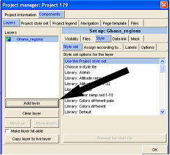
Layers, which are on top of other layers, might hide features of the layers beneath. This is particularly the case with raster maps, as they might cover all features ‘below’. To change this sequence, and to bring other features to top, use the buttons ‘Move up’ or ‘Move down’.
At the right side of this Project Manager window you see more details and settings of this layer, particularly under tab ‘Files’.
- - - - -
You can take this layer out by Right-mouse > Project manager > Project manager window: Layers > Select layer > Clear layer > OK.
- - - - -
General note: For fast access, this manual is made available in all LUPMIS installations through Main menu > Help > Useful web sites > LUPMIS manual (local). In external Map Maker installations, it can be called through the internet.
- - - - -
More reading:
'GIS Introduction for LUPMIS: Vector Data (Chapter 2)' about vector data.
'GIS Introduction for LUPMIS: Raster Data (Chapter 5)' about raster data.
LUPMIS exercise: Go to folder LUPMIS \ Ghana \ Ghana dra, and add layer Ghana roads, Ghana districts, Ghana regions etc as vector layers, from folder LUPMIS \ Kasoa \ Kasoa photos \ 336098col_utmecw.ecw as raster map.

