5.1.7 Download GPS track from Garmin - LUPMISManual
Main menu:
- 0. Introduction
- 1. GIS handling
-
2. GIS data entry
- 2.1 Create new layer
- 2.2 Digitize line
- 2.3 Digitize point
- 2.4 Digitize polygon
- 2.5 Edit existing layer
- 2.6 Delete feature
- 2.7 Split line
- 2.8 Split polygon
- 2.9 Merge lines from different layers
- 2.10 Unite lines
- 2.11 Snap lines
- 2.12 Join polygons
- 2.13 Extend polygon
- 2.14 Insert island
- 2.15 Define unit surrounding islands
- 2.16 Create 'doughnut'
- 2.17 Fill 'doughnut' polygon
- 2.18 Fill polygon with 'holes'
- 2.19 Digitize parcels from sector layout
-
3. GIS operations
- 3.1 Create buffer
- 3.2 Create exclusion zone
- 3.3 Overlay units
- 3.4 Convert line to polygon
- 3.5 Derive statistics (area size, length)
- 3.6 Clip unit according to other unit
- 3.7 Create geographic grid
- 3.8 Move entire vector map
- 3.9 Move or copy individual features on a map
- 3.10 Adjust polygon to line
- 3.11 Convert points to polygon
- 3.12 Define by distance
- 3.13 Create multiple objects
- 3.14 Transfer styles from one layer to another
-
4. Attribute database
- 4.1 Start with database
- 4.2 Import database
- 4.3 Display database information
- 4.4 Enter attribute data
- 4.5 Attribute matrix of multiple layers
- 4.6 Seeds
- 4.7 Repair attribute data
- 4.8 Merge lines with attached database
- 4.9 Transfer attribute data from points to polygons
- 4.10 Copy styles, labels, attributes
-
5. Conversion of data
-
5.1 Points
- 5.1.1 Import list of points from text file
- 5.1.2 Import list of points from Excel file
- 5.1.3 Convert point coordinates between projections
- 5.1.4 Convert point coordinates from Ghana War Office (feet)
- 5.1.5 Convert point coordinates from Ghana Clark 1880 (feet)
- 5.1.6 Track with GPS
- 5.1.7 Download GPS track from Garmin
- 5.1.8 Download GPS track from PDA
- 5.1.9 Frequency analysis of points
- 5.2 Vector maps
- 5.3 Raster maps
-
5.4 Communication with other GIS programs
- 5.4.1 Import GIS data from SHP format
- 5.4.2 Import GIS data from E00 format
- 5.4.3 Import GIS data from AutoCAD
- 5.4.4 Export LUPMIS data to other programs
- 5.4.5 Export GIS to AutoCAD
- 5.4.6 Change a shape file to GPX
- 5.4.7 Transfer GIS data to other LUPMIS installations
- 5.4.8 Digitize lines in Google Earth
- 5.5 Terrain data
- 5.6 Export to tables
- 5.7 Density map
-
5.1 Points
-
6. Presentation
- 6.1 Labels
- 6.2 Styles and Symbols
- 6.3 Marginalia
- 6.4 Legend
- 6.5 Map template
- 6.6 Final print
- 6.7 Print to file
- 6.8 3D visualization
- 6.9 External display of features
- 6.10 Google
-
7. GIS for land use planning
- 7.1 Introduction to land use planning
- 7.2 Land use mapping for Structure Plan
- 7.3 Detail mapping for Local Plan
- 7.4 Framework
- 7.5 Structure Plan
- 7.6 Local Plan
- 7.7 Follow-up plans from Local Plan
- 7.8 Land evaluation
-
8. LUPMIS Tools
- 8.1 General
-
8.2 Drawing Tools
- 8.2.1 Overview
- 8.2.2 UPN
- 8.2.3 Streetname + housenumbers
- 8.2.4 Lines
- 8.2.5 Arcs
- 8.2.6 Polygons
- 8.2.7 Points
- 8.2.8 Cut line
- 8.2.9 Other Drawing Tools
- 8.2.10 Import
- 8.2.11 Projections + conversions
- 8.2.12 Format conversion
- 8.2.13 Other GIS Tools
- 8.2.14 Utilities
- 8.3 Printing Tools
- 8.4 Permit Tools
- 8.5 Census Tools
-
8.6 Revenue Tools
- 8.6.1 Overview
- 8.6.2 Entry of revenue data
- 8.6.3 Retrieval of revenue data
- 8.6.4 Revenue maps
- 8.6.5 Other revenue tools
- 8.7 Reports Tools
- 8.8 Project Tools
- 8.9 Settings
-
9. Databases
- 9.1 Permit Database
-
9.2 Plans
- 9.2.1 Accra
- 9.2.2 Kasoa
- 9.2.3 Dodowa
- 9.2.4 Sekondi-Takoradi
-
9.3 Census Database
-
9.4 Revenue Database
-
9.5 Report Database
-
9.6 Project Database
- 9.7 Address Database
-
Annexes 1-10
- A1. LUPMIS setup
- A2. Background to cartography/raster images
- A3. Glosssary
- A4. Troubleshooting
- A5. Styles
- A6. Classification for landuse mapping/planning
- A7. GIS utilities
- A8. Map projection parameters
- A9. Regions / Districts
- A 10. Standards
-
Annexes 11-20
- A11. LUPMIS distribution
- A12. Garmin GPS
- A13. Training
- A14. ArcView
- A15. Population statistics
- A16. Entry and display of survey data
- A17. External exercises
- A18. Programming
- A19. Paper sizes
- A20. Various IT advices
- A21. Site map and references
5.1.7 Download GPS Track from Garmin GPS
Level of expertise required for this Chapter: Intermediate; general Map Maker training
For Garmin GPS 76: Prior to connecting the Garmin GPS 76 to the computer, you have to install the driver to enable the communication between the GPS and the computer (see Annex 1.3).
For Garmin GPS 62 or 62s: There is no need of installing a driver. You have to set it up only once initially, then can go to the field, and download the data into GIS / LUPMIS.
See Chapter 5.1.6 for the procedure to track in the field.
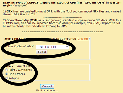
Preferred option for the Garmin GPS 62 and 62s, with LUPMIS installed, is the LUPMIS Drawing Tool: Import GPS > GPX from GPS:
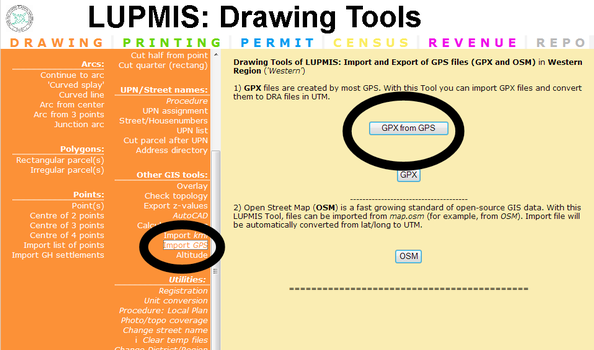
> Select the drive letter of the GPS (it should be displayed automatically, if drive G-O) > Garmin > GPX > Select track file > 'Select' > Choose point or line or polygon > Convert
The result will be a DRA file in the correct projection (UTM 30) in folder LUPMIS\LUPMISTemp.
- - - - -
Alternatively (without LUPMIS):
1. Turn GPS on. (See also Annex 12, to set up the GPS and remarks on tracking).
1a. If you have a Garmin GPS 62s: You have to 'Save the current' track
2. Connect GPS to computer via download cable
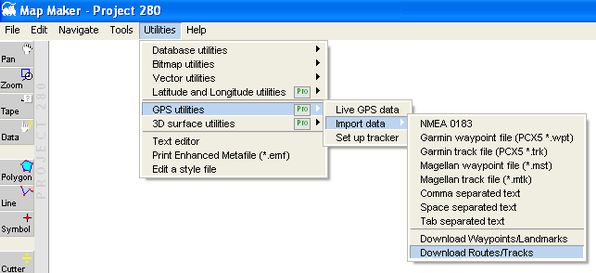
3. In Map Maker: Main menu > Utilities > GPS Utilities > Import data >
For Garmin GPS 62 or 62s:
3a. > GPX >
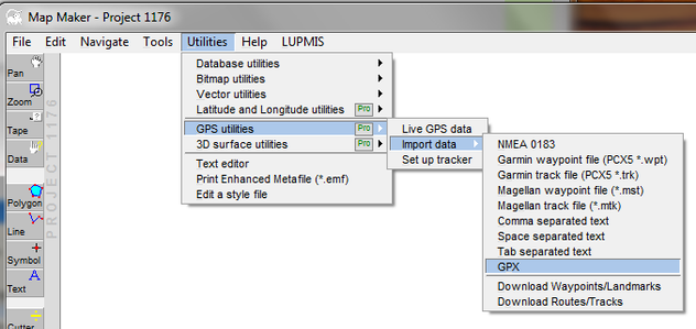
For Garmin 76:
3b. > Download routes / tracks >
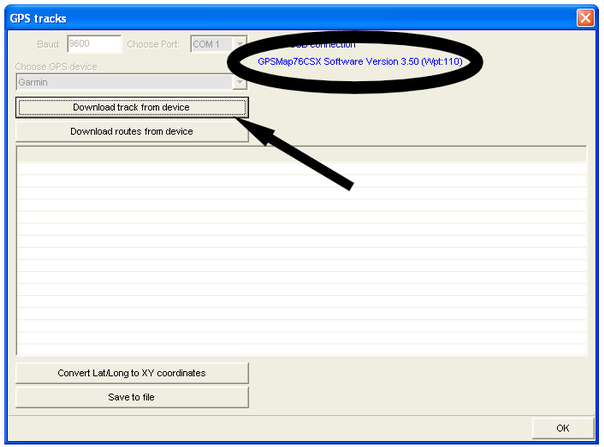
Only if communication by serial (not by USB cable): Check, that baud rate is on 9600, GPS device on Garmin. First, try COM, port, if this fails, try the other COM settings.
> Check that the communication to the GPS is established (for example, display of GPS… software version, see below) >
If communication is not established, install driver (see Annex 1.3).
> Download track from device >
After a few minutes, point coordinates will be displayed:
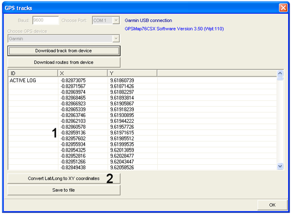
> If coordinates are in lat/long, with numbers smaller than 10 (1, see above): Convert Lat/Long to XY coordinates (2) > Choose map projection window: UTM 30 >
(If UTM 30 is not shown, you have to set up UTM 30 as projection, see Annex 1.1.5)
> Save to file (3) > Select as file type: 'Map Maker drawing file (*.DRA)’ > OK
Note: If the GPS does not have a USB port, but communication runs through (old-fashioned) serial port, there is no need to install a driver.
It is recommended to delete the GPS memory after downloading (at the Garmin GPS: PAGE till you reach ‘Tracks’ screen > Navigate to ‘Clear’ and ENTER > Confirm with Yes).
- - - - -
If you have successfully installed the driver, but the message does not appear in Map Maker, you might have a GPS which can not communicate easily through USB (e.g. Garmin 78). In Map Maker, you can convert the GPX file through Utilities > GPS Utilities > Import data > GPX and call the file in your GPS.
Alternatively, you can use the LUPMIS Drawing Tool (if installed): Import OSM/GPX.
- - - - -
The procedure to download points collected by the GPS (‘waypoints’) is very similar. You only have to select ‘Download Waypoints/Landmarks’ instead of ‘Download routes/tracks’ in step 3 above.

