A16.1 Survey: Summary - LUPMISManual
Main menu:
Annex 16: Entry and Display of Survey Data
Level of expertise required for this Chapter: Intermediate; general Map Maker training
Units can also be entered with their coordinates or data, as collected in the field by traditional, ‘old-fashioned’ survey techniques. The entry of polygons and lines through this method can be more precise, if conducted over short distances, but is more labor-intensive, more error prone and slower.
A menu-driven user-friendly entry system has been established at LUPMIS Drawing Tools (see Chapter 8.2).
A16.1 Survey: Summary
The approach: Entry of data in .XY file --> Convert to DRA file.
1. Have a listing or sketch of all points, which define the polygon(s) or line(s). These data can be:
Coordinates of each point, or
Distance – bearing of each point, starting from a known point, or
Distance – bearing of each point, starting from some distance / bearing from a know point, or
Distance – bearing of each point, starting from two points with their bearings,
etc
- - - - -
2. It is recommended to use the Map Maker internal text editor to enter the data:
Main menu > Utilities > Text editor > Select type: Map Maker survey data (.xy) > Select folder > Specify file name for new file > Save
Alternatively, you can use WordPad, Notepad or any other text (ASCII) editor.
- - -
2.A) If you have the coordinates of each point of a polygon or line, enter each point (1,2...n) with its x and y coordinates in one line, separated by comma, and the name of the unit in the first line. The syntax reads as:
Name of polygon,x1,y1
x2,y2
x3,y3
…
xn,yn
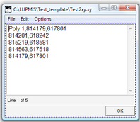
For example (see below):
MyPlot, 814179,617801
814201,618242
815219,618581
814563,617518
814179,617801
If the last point is equal to the first point, it will be a polygon, otherwise a line.
- - -
2.B) If you draw a polygon or line starting from a known point (1), with all next points surveyed the old-fashioned way through distance – bearing (2,3…n), the syntax is:
COMPASS TRAVERSE
Name of line,x1,y2
bearing1,distance1
bearing2,distance2
…
bearing n,distance n
For example:
COMPASS TRAVERSE
MyOtherPlot, 814179,617801
90,45
175,32
261,35
If the last line segment reaches the starting point, it will be a polygon, otherwise a line. In practice, there will be a discrepancy. If you add the word CLOSE to the bottom, Map Maker will spread the error proportionally among the other points in the polygon.
For example:
COMPASS TRAVERSE
MyOtherPlot, 814179,617801
90,45
175,32
261,35
CLOSE
See Annexes 16.2 and 16.3 for full description and samples of the traverse methods.
- - -
2.C) If you draw a polygon or line starting from a point (2), which has a know distance – bearing from a known point (1), with all next points surveyed through distance – bearing (3,4…n), the syntax is:
POLAR,x1,y1
Name of line,bearing2,distance2
bearing3,distance3
bearing4,distance4
…
bearingn,distancen
If the last line segment reaches the starting point, it will be a polygon, otherwise a line.
- - - - -
2.D) There are more entry options. See the documentation in the official manual of Map Maker or contact LUPMIS. See also Annexes 16.2 - 16.5 for samples.
Compass bearing method: Distance-bearing readings for all points of a surveyed polygon, starting from two reference points known by their x-y-coordinates
Relative angles method: Same as above, but the first point of the surveyed polygon is measured in an angle to the base line between the two reference points (not in North bearing)
Relative polar coordinates method: Same as above, but all angles are in reference to the base line between the two reference points (not in N bearing)
Distance method: Only the distances of all points of the surveyed polygon from the two reference points are used, no bearings at all.
Angle traverse method: Similar to the compass traverse method (see para 2.B above), but all angles are relative to the previous angles, not in North bearing.
Offset method: An object is defined by its 90º offset from a point on a straight line between the two reference points
- - - - -
3. Press <Enter> at the end to close the last line.
Having entered all data, you must save the file (File > Save > OK)
Be sure, that the saved file has the extension XY, not TXT.
4. Use the import facility of Map Maker:
Main menu > Utilities > Vector utilities > Import files > Map Maker survey (*.XY) > Import Map Maker survey data, step 1 window: Choose source XY file > Select folder and file > Open > Next step > Step 2 window: Choose target file > Specify file name > Save > Finish > Do you want to check polygon topology: Yes > Confirm save
The new DRA file can now be displayed and processed.
- - - - -
LUPMIS exercises:
1. Modern surveyors use high-accuracy GPS to survey a parcel. They came back from the field with following coordinates: 780491/611165, 780517/611170, 780523/611133, 780497/611129. Transfer to Map Maker and display with background orthophotomap (if available).
2. Old survey reports show following distance-bearings for a parcel: 171.0º/36.65m, 260.3º/26.45m, 351.3º/36.49m, 79.9º/26.30m, with start at 780517/611170. Transfer to Map Maker.
3. How do these two plots compare?
4.Prepare a draft survey report of this parcel (UPN 780-0611-0053).
5. Another exercise: The surveyed plot has following distance-bearings, starting at x 784791, y 607700: 90º, 100m - 180º,50m - 90º,50m - 180º,100m - 270º,150m. What is the last line to close the parcel? Transfer to Map Maker.

