5.4.8 Digitize lines in Google Earth - LUPMISManual
Main menu:
- 0. Introduction
- 1. GIS handling
-
2. GIS data entry
- 2.1 Create new layer
- 2.2 Digitize line
- 2.3 Digitize point
- 2.4 Digitize polygon
- 2.5 Edit existing layer
- 2.6 Delete feature
- 2.7 Split line
- 2.8 Split polygon
- 2.9 Merge lines from different layers
- 2.10 Unite lines
- 2.11 Snap lines
- 2.12 Join polygons
- 2.13 Extend polygon
- 2.14 Insert island
- 2.15 Define unit surrounding islands
- 2.16 Create 'doughnut'
- 2.17 Fill 'doughnut' polygon
- 2.18 Fill polygon with 'holes'
- 2.19 Digitize parcels from sector layout
-
3. GIS operations
- 3.1 Create buffer
- 3.2 Create exclusion zone
- 3.3 Overlay units
- 3.4 Convert line to polygon
- 3.5 Derive statistics (area size, length)
- 3.6 Clip unit according to other unit
- 3.7 Create geographic grid
- 3.8 Move entire vector map
- 3.9 Move or copy individual features on a map
- 3.10 Adjust polygon to line
- 3.11 Convert points to polygon
- 3.12 Define by distance
- 3.13 Create multiple objects
- 3.14 Transfer styles from one layer to another
-
4. Attribute database
- 4.1 Start with database
- 4.2 Import database
- 4.3 Display database information
- 4.4 Enter attribute data
- 4.5 Attribute matrix of multiple layers
- 4.6 Seeds
- 4.7 Repair attribute data
- 4.8 Merge lines with attached database
- 4.9 Transfer attribute data from points to polygons
- 4.10 Copy styles, labels, attributes
-
5. Conversion of data
-
5.1 Points
- 5.1.1 Import list of points from text file
- 5.1.2 Import list of points from Excel file
- 5.1.3 Convert point coordinates between projections
- 5.1.4 Convert point coordinates from Ghana War Office (feet)
- 5.1.5 Convert point coordinates from Ghana Clark 1880 (feet)
- 5.1.6 Track with GPS
- 5.1.7 Download GPS track from Garmin
- 5.1.8 Download GPS track from PDA
- 5.1.9 Frequency analysis of points
- 5.2 Vector maps
- 5.3 Raster maps
-
5.4 Communication with other GIS programs
- 5.4.1 Import GIS data from SHP format
- 5.4.2 Import GIS data from E00 format
- 5.4.3 Import GIS data from AutoCAD
- 5.4.4 Export LUPMIS data to other programs
- 5.4.5 Export GIS to AutoCAD
- 5.4.6 Change a shape file to GPX
- 5.4.7 Transfer GIS data to other LUPMIS installations
- 5.4.8 Digitize lines in Google Earth
- 5.5 Terrain data
- 5.6 Export to tables
- 5.7 Density map
-
5.1 Points
-
6. Presentation
- 6.1 Labels
- 6.2 Styles and Symbols
- 6.3 Marginalia
- 6.4 Legend
- 6.5 Map template
- 6.6 Final print
- 6.7 Print to file
- 6.8 3D visualization
- 6.9 External display of features
- 6.10 Google
-
7. GIS for land use planning
- 7.1 Introduction to land use planning
- 7.2 Land use mapping for Structure Plan
- 7.3 Detail mapping for Local Plan
- 7.4 Framework
- 7.5 Structure Plan
- 7.6 Local Plan
- 7.7 Follow-up plans from Local Plan
- 7.8 Land evaluation
-
8. LUPMIS Tools
- 8.1 General
-
8.2 Drawing Tools
- 8.2.1 Overview
- 8.2.2 UPN
- 8.2.3 Streetname + housenumbers
- 8.2.4 Lines
- 8.2.5 Arcs
- 8.2.6 Polygons
- 8.2.7 Points
- 8.2.8 Cut line
- 8.2.9 Other Drawing Tools
- 8.2.10 Import
- 8.2.11 Projections + conversions
- 8.2.12 Format conversion
- 8.2.13 Other GIS Tools
- 8.2.14 Utilities
- 8.3 Printing Tools
- 8.4 Permit Tools
- 8.5 Census Tools
-
8.6 Revenue Tools
- 8.6.1 Overview
- 8.6.2 Entry of revenue data
- 8.6.3 Retrieval of revenue data
- 8.6.4 Revenue maps
- 8.6.5 Other revenue tools
- 8.7 Reports Tools
- 8.8 Project Tools
- 8.9 Settings
-
9. Databases
- 9.1 Permit Database
-
9.2 Plans
- 9.2.1 Accra
- 9.2.2 Kasoa
- 9.2.3 Dodowa
- 9.2.4 Sekondi-Takoradi
-
9.3 Census Database
-
9.4 Revenue Database
-
9.5 Report Database
-
9.6 Project Database
- 9.7 Address Database
-
Annexes 1-10
- A1. LUPMIS setup
- A2. Background to cartography/raster images
- A3. Glosssary
- A4. Troubleshooting
- A5. Styles
- A6. Classification for landuse mapping/planning
- A7. GIS utilities
- A8. Map projection parameters
- A9. Regions / Districts
- A 10. Standards
-
Annexes 11-20
- A11. LUPMIS distribution
- A12. Garmin GPS
- A13. Training
- A14. ArcView
- A15. Population statistics
- A16. Entry and display of survey data
- A17. External exercises
- A18. Programming
- A19. Paper sizes
- A20. Various IT advices
- A21. Site map and references
5.4.8 Digitize lines in Google Earth
Level of expertise required for this Chapter: Advanced; general Map Maker training
Before you start digitizing, you have to check, if Google Earth is installed, its resolution is good enough to recognize all structures and the horizontal accuracy is better than 10 m (for example, against the GPS). If these criteria are not met, digitizing is not recommended.
1. In Google Earth:
Load Google Earth > Zoom to area of interest (You can zoom in by +, out by -, move in all four directions (N, S, W, E) with the arrow keys. The indicated altitude should not exceed 3 km) > Add (1, see below) > Path > Google Earth – New window: Give name (2, see below) > Start digitizing by clicking the mouse on each bend, thus creating vertices.
If you like to change a digitized point, you can locate the point, and drag it to a new position. Afterwards, you have to click on the last point to continue with digitizing.
At the end of the line, you press Ok at the bottom >
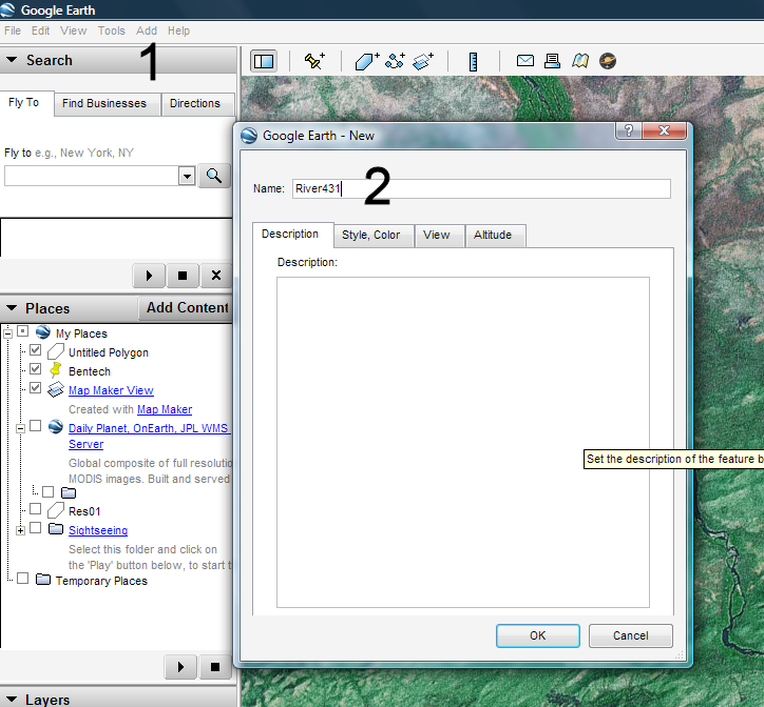
> In ‘Places’ on the left side, you will find the newly created layer (under ‘My places’) > right-click > Save As … , or Save place as … > Save as type: KML > Select folder > Accept or rename file name > Save
If you want to edit a line after having finished digitizing, you click right-mouse on this track in ‘Places’ > Properties, and you are back to the editing mode. After having closed the line, do not forget to save it again as KML file.
After this step 1, you have two alternatives to proceed and to convert the KML file to Map Maker:
Either with step 2 using the LUPMIS Tools or with step 2-4-ALTERNATIVE using GPSUtility software. Both of these alternative steps are explained below.
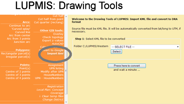
2. If you have LUPMIS Tools, the preferred option is the tool 'Import KML' of the Drawing Tools. This will directly convert the KML file to a DRA file, and also convert it to UTM, if the KML file is in lat/long (as digitized in Google Earth).
- - - - -
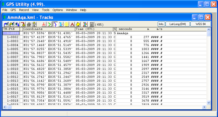
2-ALTERNATIVE. With the software GPSUtility, convert KML file to SHP file. (See Annex 7 for utilities).
Load GPSUtility > License conditions for GPS Utility window: Yes (You can OK any other messages before that) > GPSUtility window: File > Open > Open window: Select Files of Type: Google Earth (kml, kmz) > Select folder and file > Open > Confirm window: Yes >
The imported data display should like this:
> File > Save/Export options > Save / Export / Print Options window: Select Format: Shape fileset (SHP+SHX,DBF)(1, see below) > Export As (2) >
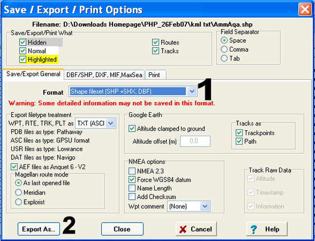
> Save as window: Select folder > Specify file name > Check, that specified file type is still SHP etc > Save. Finished! > File > Exit
3-ALTERNATIVE. In Map Maker, convert SHP file to DRA file: Main menu > Utilities > Vector utilities > Import file > ArcView Shape file > Step 1 of 3 window: Choose source SHP file > Select folder, file > Open > Next step > Step 2 of 3 window: Use serial number as object ID > Next step > Step 3 of 3 window: Choose target file > Select folder > Accept or change file name > Save > Finish > Confirm save
Finished! For checking purposes, you then download this file in Map Maker by: Right-mouse > Add layer > Select folder and file (DRA file) > Open > OK. You should be able to see your digitized line. Then, Main menu > File > View in Google Earth, to see and check it with the original feature.
4-ALTERNATIVE. In Map Maker, you will, see if the imported line is in latitude / longitude or in UTM. If in lat / long, you must project it to UTM (see Chapter 5.2.4).

