6.5 Map template - LUPMISManual
Main menu:
6.5 Map Template
Level of expertise required for this Chapter: Advanced; specifically for LUPMIS @ TCPD
The frame around the map, the entire layout on a page, the grid, and geographical references can all be defined in a map template.
The standard layout, i.e. templates, for all standard land use planning maps (Frameworks, Structure Plans, Local Plans, land use maps) will be supplied by TCPD-HQ / LUPMIS. To have a conform approach for all TCPD land use plans, it is not recommended to change these standard layouts.
All map templates require graphic support files (in folder C:\LUPMIS\LUPMISPrograms\GraphicSupport, supplied by TCPD-HQ).
Note 1: Template files are stored in folder C:\LUPMIS\LUPMISPrograms\Templates (see Annex 1.1.1 to load them, Annex 1.1.8 to check). Graphic support files are in folder C:\LUPMIS\LUPMISPrograms\GraphicSupport (see Annex A 1.1.1 to load them). For distribution, see Annex 11.
Note 2: There are two template formats in Map Maker. GEO template files might be faulty, you better use the PTP format. You can convert GEO to PTP through Main menu > File > Page templates > Export template.
Note 3: Don't confuse these 'map templates' with LUPMIS's 'planning templates'.
- - - - -
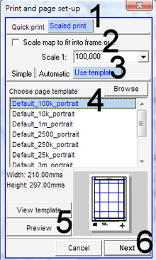
6.5.1 Load Template for Print
The print layout is loaded at the print option: Main menu > File > Print > (You might want to choose your printer and format) > Print and page set-up window: Scaled print (1, see below) > (You might want to change the scale, 2) > Use template (3) > Choose template (4) > Preview (5) > At the preview screen, you can also zoom, pan, display entire image through buttons at very bottom right of screen. Check in particular the spacing of numbers for grid and graticule > Close by X at top right > Next (6) > Print
6.5.2 Create Template
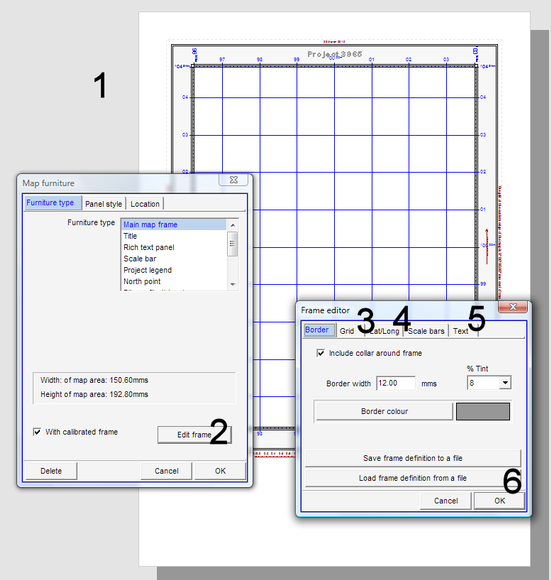
For specific maps, you can also create your own map template: Main menu > File > Page templates > New template > Sheet or panel size window: Size: Current printer paper > Choose type: With calibrated main map frame > OK > Template design view (1, see below): Right-click on map frame > Map furniture window: Edit frame (2) > Frame editor window: Grid (3) > You can define the grid interval ('Automatic' or according to table) or other parameters > Lat/long (4) > You can define the major graticule interval (according to table) or other parameters > Text (5) > Define parameters > Ok (6) >
> Move the cursor to the bottom / right edge of the map frame, where the hand changes to an arrow and resize (decrease) the area of the map frame, so you have space for legend and other marginalia at the bottom / right > Insert legend, north arrow, LUPMIS remark, TCPD logo etc like any other map furniture (see Chapter 6.3.1) >
> Main menu > File > Save template as > Choose folder > Specify file name for template > Save
Scale |
Example |
Grid (UTM) |
Graticule (lat/long ) |
1:10,000,000 |
500,000 m |
5 deg |
|
1:2,000,000 - |
Many maps of Ghana |
100,000 m |
1 deg |
1:1,000,000 |
National SDF |
50,000 m |
30 min |
1:500,000 |
National SDF |
10,000 m |
15 min |
1:250,000 |
10,000 m |
10 min |
|
1:200,000 |
10,000 m |
5 min |
|
1:100,000 |
Many District SDF Plans |
5,000 m |
5 min |
1:75,000 |
1,000 m |
5 min |
|
1:50,000 |
1,000 m |
1 min |
|
1:25,000 |
Most Structure Plans |
1,000 m |
30 sec |
1:10,000 |
500 m |
15 sec |
|
1:5,000 |
100 m |
10 sec |
|
1:2,500 |
Local Plans |
100 m |
5 sec |
1:1,000 |
50 m |
1 sec |
Location map (see Chapter 6.3.3) and detail map (see Chapter 6.3.4) can’t be placed on a map template, only on a Map Maker project.

