A2.2 Projection and datum - LUPMISManual
Main menu:
A2.2 Projection and Datum
Level of expertise required for this Chapter: Intermediate; specifically for LUPMIS @ TCPD
This Chapter is a modified reprint of the Design Report of LUPMIS with additional remarks for the War Office in Chapter A2.2.4.
A2.2.1 Introduction
There are various projections and datum definitions, which are or have been applied in Ghana and result in some confusion and inaccuracy of mapping and surveys.
(Technical definition: A datum is a set of reference points on the earth's surface against which position measurements are made, and (often) an associated model of the shape of the earth (ellipsoid) to define a geographic coordinate system. Horizontal datums are used for describing a point on the earth's surface, in latitude and longitude or another coordinate system. Vertical datums measure elevations or depths'. A datum is defined by the ellipsoid and the shift of the x,y,z origin).
One of the first datum was the Accra Datum 1929 used for the ellipsoid of War Office 1926 (also McCaw 1924), which can still be found on recent maps (e.g. on some 1:2,500 topo). Earlier maps had imperial units (‘Gold Coast feet’, not UK feet, equals 0.3047997 m), recent maps have metric units. The War Office projection (rectangular polyconic projection) has been defined 1853 and was mainly used in the late 19 century.
In 1977 the datum was changed to Leigon Datum 1977 used for the ellipsoid of Clarke 1880 (modified). This system is shown on some current maps (e.g. on some 1:50,000 topo), all with metric units.
‘The problem of incompatible projections and conversion between mapping systems is of general concern to those involved in the collection of natural resources data. The Ghana National Grid (GNG) is an example of a mapping system that is not defined in image processing and GIS software and for which the transformation parameters are not readily available in the literature. Consequently, integrating GNG topographic map data within a GIS with data derived from other sources can be problematic.’
The problem of having different datums was not recognized as a major problem in the past, because most GIS applications have been applied on small or medium scales, where errors due to different datums of upto 100-500 m do not show.
Agencies (LSAs) or institutes have different requirements for the tolerance of acceptable error, depending on the operating scale, either larger or smaller scales. At the NLIS, with mapping and inventories of parcels and cadastres, higher accuracy than the beforementioned of 100-500 m is required, together with high compatibility.
For map data at LUPMIS, a maximum error of 5 m can be accepted, which is derived from a compromise between cost efficiency and financial sustainability, projection and datum definitions, (handheld) GPS accuracy (DOP), map reading skills of surveyors, i.e. at the maximum scale of 1:2,500, and the accuracy to be expected for the tasks of TCPD.
To be precise at that accuracy level, consistent within the NLIS, and technologically applicable, the Consultant strongly recommends to update and use a national grid (including projection and datum) as fast as possible for all mapping activities in Ghana, to be used with all GPS and on all GIS software, which is also easy to use, well documented and in accordance with international standards.
Technical note: If a higher horizontal accuracy is required, following requirements exist:
For maximum of 3 m positional error: All (handheld) GPS have to be equipped with a high accuracy chip (e.g. Sirf III for PDA/GPS), all image data have to be re-georeferenced with newly collected ground control points, newly acquired images have to meet the 'Precision' level of imagery (CE90: 4.1 m, RMS: 1.9 m), collected vector maps have to be checked and also re-georeferenced (either with conversion parameters, or re-calibrated)
For a submeter positional accuracy: GPS have to be single-frequency or dual-frequency GPS retriever or data from handheld GPS to be postprocessed, if synchronous GPS data from a reference base station within a distance of less than 20-30 km (for single-frequency) or 50-100 km (for dual-frequency) are available, all image data have to be re-georeferenced with newly collected ground control points, newly acquired images (only QuickBird) have to meet the 'PrecisionPlus' level of imagery (CE90: 2.0 m, RMS: 0.9 m), collected vector maps have to be checked and also re-georeferenced (either with conversion parameters, or re-calibrated
A2.2.3 WGS 84 and UTM
WGS84 is the most commonly used contemporary datum, based on highly accurate and most recent measurement of the shape of the earth. WGS84 is the default standard datum for coordinates stored in all commercial GPS units. It is also incorporated in all GIS software. This will enable the professional and easy use of GPS and GIS. Many GPS do not enable the collection of data on other systems than the WGS 84.
The same system can also be applied by LIS (LAP) and all LSAs.
Differences of point coordinates measured by different datums and projections can amount to the range of seconds, i.e. 300 m or more, well beyond the accuracy of GPS.
The UTM system is the highest standard of projection applied worldwide, with a high level, well-defined accuracy (below 1 part in 1,000). It is easy to handle in the field due to its units of meters. Most, if not all of the neighbouring countries of Ghana use the UTM system. Introducing and implementing the UTM projection is therefore also in accordance with the other countries of the region. The use of UTM is also in fulfillment of the Africa Reference Framework (AFREF) initiative in Ghana and Africa in general.
Recently, the GTM (Ghana Transverse Mercator projection) has been promoted by the Survey & Mapping Division of the Lands Commission, Ghana. The publication of the parameters will be experted soon.
A2.2.4 Proposed projection and datum for Ghana
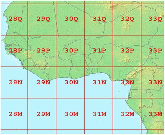
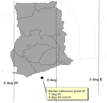
In Ghana, UTM zone 30 applies (see figure below). Beside these many advantages of applying such a precise, most up-to-date system, the only disadvantage might be a slightly higher error in the extreme East of the country, if zone 30 is applied on a national scale. On large scale, maps can easily be transferred to UTM zone 31 in these few areas in the extreme East to resolve this problem.
At TCPD, the Consultant recommends the UTM projection based on WGS 84, in order to apply a modern, adequate system, which is accurate, has not to be changed within a few years and which can easily be used by surveyors and planners in the field with GPSs.
| Ghana Grid | Ghana Grid | Ghana Grid A | Ghana Grid B | |
Projection: | TM | TM | UTM | GTM | |
| Origin W/E (deg) | -1 | -1 | -3 | -1 | |
| Origin N (deg) | 4.666,66 | 4.666,66 | 0 | 0 | |
| Origin scale | 0.999,75 | 0.999,75 | 0.999,60 | 0.999,75 | |
| False coord x E (m) | 274,320 | 300,000 | 500,000 | 400,000 | |
| False coord y N (m) | 0 | 0 | 0 | 0 | |
Datum (conversion to WGS 84): | Accra 1929 (1) | Leigon 1977 | WGS 84 | ? | |
| Shift dx (m) (2) | -199 | - 130 | - | ||
| Shift dy (m) (2) | 32 | 29 | - | ||
| Shift dz (m) (2) | 322 | 364 | - | ||
| da (m) (3) | - 81.5 | - 56 | - | ||
| df (*10exp-4) (4) | - 0.255 | - 0.547 | |||
| Rotation rx (5) | ? | ? | |||
| Rotation ry (5) | ? | ? | |||
| Rotation rz (5) | ? | ? | |||
| Datum scale (ppm) (5) | ? | ? | |||
Ellipsoid: | War Office | Clarke 1880 | WGS 84 | ||
| Semi-major axis (a, m) | 6,378,300.00 | 6,378,249.145 | 6,378,137.00 | ||
| Semi-minor axis (b, m) | 6,356,751.690 | 6,356,514.870 | 6,356,752.314 | ||
| Flattening (1/f) | 296.000 | 293.465 | 298.257 | ||
| Eccentricity (e) | 0.082,130,04 | 0.082,483,40 | 0.081,819,19 | ||
| 2nd eccentricity (e') | 0.082,408,45 | 0.082,765,43 | 0.082,094,44 | ||
Notes:
(1) In earlier days, the War Office 1853 datum was used
(2) Local datum shift is based on literature research (see footnote above)
(3) Calculated as a (WGS84) / 2 - a(ellipsoid) / 2, useful for User Datum definitions at GPS and GIS
(4) Calculated as f(WGS84) - f(ellipsoid) ) * 10,000, useful for User Datum definitions at GPS and GIS
(5) Rotation parameters and datum scale are required for accurate 7-parameter transformation (Helmert, Bursa-Wolf), but not for 5-parameter transformation (geocentric translation, Molodensky)
A2.2.5 War Office
A2.2.6 Considerations for application
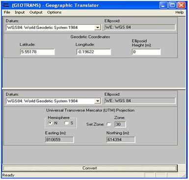
The coordination conversion package Geographic Transformer to convert to / from different projections and datums is highly recommended for the ease of its use.
This software has been ‘fudged’ (i.e. adjusted based on empirical error minimization), but research still takes place (as of October 2007) to adjust the conversion to / from War Office definition in precise, geodetic terms. Alternatively, different conversion software with predefined War Office conversion has to be searched for, and procured, to enable - at least in the interim period - a conversion from collected GPS coordinates to the War Office system to be done with the expected accuracy.
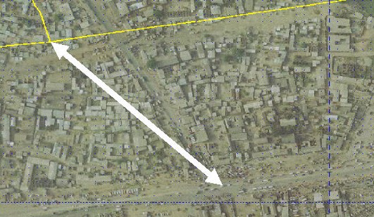
Demonstration of georeference distortion:
The orthophoto of Kasoa has been sampled from War Office,
the yellow line in the upper part of the photo is the track of the road with GPS / WGS 84 (in lat/long).
Distance between these two presentations of the same location is 120-150 m
- - - - -
Currently available projections parameters are listed in Annex 8.
More reading:
'GIS Introduction for LUPMIS: Coordinate System (Chapter 7)'.

