3.7 Create geographic grid - LUPMISManual
Main menu:
- 0. Introduction
- 1. GIS handling
-
2. GIS data entry
- 2.1 Create new layer
- 2.2 Digitize line
- 2.3 Digitize point
- 2.4 Digitize polygon
- 2.5 Edit existing layer
- 2.6 Delete feature
- 2.7 Split line
- 2.8 Split polygon
- 2.9 Merge lines from different layers
- 2.10 Unite lines
- 2.11 Snap lines
- 2.12 Join polygons
- 2.13 Extend polygon
- 2.14 Insert island
- 2.15 Define unit surrounding islands
- 2.16 Create 'doughnut'
- 2.17 Fill 'doughnut' polygon
- 2.18 Fill polygon with 'holes'
- 2.19 Digitize parcels from sector layout
-
3. GIS operations
- 3.1 Create buffer
- 3.2 Create exclusion zone
- 3.3 Overlay units
- 3.4 Convert line to polygon
- 3.5 Derive statistics (area size, length)
- 3.6 Clip unit according to other unit
- 3.7 Create geographic grid
- 3.8 Move entire vector map
- 3.9 Move or copy individual features on a map
- 3.10 Adjust polygon to line
- 3.11 Convert points to polygon
- 3.12 Define by distance
- 3.13 Create multiple objects
- 3.14 Transfer styles from one layer to another
-
4. Attribute database
- 4.1 Start with database
- 4.2 Import database
- 4.3 Display database information
- 4.4 Enter attribute data
- 4.5 Attribute matrix of multiple layers
- 4.6 Seeds
- 4.7 Repair attribute data
- 4.8 Merge lines with attached database
- 4.9 Transfer attribute data from points to polygons
- 4.10 Copy styles, labels, attributes
-
5. Conversion of data
-
5.1 Points
- 5.1.1 Import list of points from text file
- 5.1.2 Import list of points from Excel file
- 5.1.3 Convert point coordinates between projections
- 5.1.4 Convert point coordinates from Ghana War Office (feet)
- 5.1.5 Convert point coordinates from Ghana Clark 1880 (feet)
- 5.1.6 Track with GPS
- 5.1.7 Download GPS track from Garmin
- 5.1.8 Download GPS track from PDA
- 5.1.9 Frequency analysis of points
- 5.2 Vector maps
- 5.3 Raster maps
-
5.4 Communication with other GIS programs
- 5.4.1 Import GIS data from SHP format
- 5.4.2 Import GIS data from E00 format
- 5.4.3 Import GIS data from AutoCAD
- 5.4.4 Export LUPMIS data to other programs
- 5.4.5 Export GIS to AutoCAD
- 5.4.6 Change a shape file to GPX
- 5.4.7 Transfer GIS data to other LUPMIS installations
- 5.4.8 Digitize lines in Google Earth
- 5.5 Terrain data
- 5.6 Export to tables
- 5.7 Density map
-
5.1 Points
-
6. Presentation
- 6.1 Labels
- 6.2 Styles and Symbols
- 6.3 Marginalia
- 6.4 Legend
- 6.5 Map template
- 6.6 Final print
- 6.7 Print to file
- 6.8 3D visualization
- 6.9 External display of features
- 6.10 Google
-
7. GIS for land use planning
- 7.1 Introduction to land use planning
- 7.2 Land use mapping for Structure Plan
- 7.3 Detail mapping for Local Plan
- 7.4 Framework
- 7.5 Structure Plan
- 7.6 Local Plan
- 7.7 Follow-up plans from Local Plan
- 7.8 Land evaluation
-
8. LUPMIS Tools
- 8.1 General
-
8.2 Drawing Tools
- 8.2.1 Overview
- 8.2.2 UPN
- 8.2.3 Streetname + housenumbers
- 8.2.4 Lines
- 8.2.5 Arcs
- 8.2.6 Polygons
- 8.2.7 Points
- 8.2.8 Cut line
- 8.2.9 Other Drawing Tools
- 8.2.10 Import
- 8.2.11 Projections + conversions
- 8.2.12 Format conversion
- 8.2.13 Other GIS Tools
- 8.2.14 Utilities
- 8.3 Printing Tools
- 8.4 Permit Tools
- 8.5 Census Tools
-
8.6 Revenue Tools
- 8.6.1 Overview
- 8.6.2 Entry of revenue data
- 8.6.3 Retrieval of revenue data
- 8.6.4 Revenue maps
- 8.6.5 Other revenue tools
- 8.7 Reports Tools
- 8.8 Project Tools
- 8.9 Settings
-
9. Databases
- 9.1 Permit Database
-
9.2 Plans
- 9.2.1 Accra
- 9.2.2 Kasoa
- 9.2.3 Dodowa
- 9.2.4 Sekondi-Takoradi
-
9.3 Census Database
-
9.4 Revenue Database
-
9.5 Report Database
-
9.6 Project Database
- 9.7 Address Database
-
Annexes 1-10
- A1. LUPMIS setup
- A2. Background to cartography/raster images
- A3. Glosssary
- A4. Troubleshooting
- A5. Styles
- A6. Classification for landuse mapping/planning
- A7. GIS utilities
- A8. Map projection parameters
- A9. Regions / Districts
- A 10. Standards
-
Annexes 11-20
- A11. LUPMIS distribution
- A12. Garmin GPS
- A13. Training
- A14. ArcView
- A15. Population statistics
- A16. Entry and display of survey data
- A17. External exercises
- A18. Programming
- A19. Paper sizes
- A20. Various IT advices
- A21. Site map and references
3.7 Create Geographic Grid
Level of expertise required for this Chapter: Beginner; general Map Maker training
The new Unique Parcel Numbering (UPN) system – and also other features – depends on the geographical grid of UTM with a grid distance of 1 km. The design of a grid (based on UTM 30) is therefore very useful. See also Chapter 7.8.1 on UPN and the importance of the UTM-grid on Local Plan follow-up.
A) Generate the grid:
1. Calculate:
Size (width, height) of the grid cells (square boxes) (1)
Number of rows and columns the grid should have (2,3)
Easting (x value), where the grid should start in the West (in UTM coordinates) (4)
Northing (y value), where the grid should start in the North (in UTM coordinates) (5)
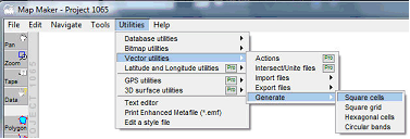
2. In Map Maker:
Main menu > Utilities > Vector utilities > Generate > Square cells >
Generate square cells window: Edge of square: Width (= height) of the grid cell (1, see below, in this example: 1000 m) > Rows: Enter number of rows (2) > Columns: Enter number of columns (3) > Left x: Enter the western edge (4) > Top y: Enter the northern edge (5) > OK >
Select folder > Define new file name > Save.
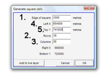
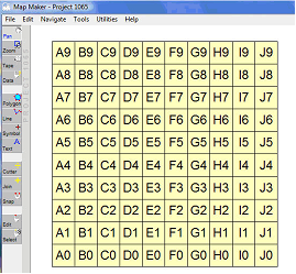
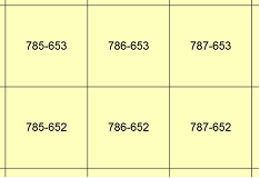
In the example below, a grid cell layer has been created with a matrix of 10 x 10, each cell 1000 m wide and high, by default numbered with an A1-based code.
- - - - -
B) Assign labels:
If you want a more meaningful label in each grid cell, for example, the geographical coordinates to be used for the UPN system, you can assign them automatically: Copy the grid cell layer to the live layer > right-mouse > Live layer actions > IDs and labels > Generate Display labels based on coordinate > OK >
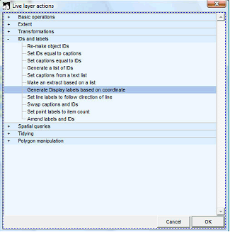
Generate Display labels based on co-ordinate windows: Select the resolution of the coordinates, in a 1 km grid this would be the ‘Kilometer resolution’ > OK
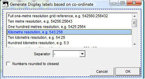
You have now created the coordinates in the label: The first three digits are the x (Easting) value, the last three digits are the y (Northing) of each cell.
- - - - -
In a similar way, you can create a grid for War Office projection (see Annex 8).
1. You first generate a grid as explained above, disregarding the projection you are in.
2. You then convert it, specifying it as ‘Ghana Grid’ projection, to UTM 30. Main menu > Utilities > Latitude and Longitude utilities > XY file to another projection > Vector > Choose source map projection window: Ghana Grid > OK > Select folder and file > Open > Choose target map projection window: UTM 30 > OK > Choose folder > Specify new file name > OK
See also Chapter 5.2.2 for conversion.
3. You can now display or process it in your standard LUPMIS configuration like any other layer.
- - - - -
See references to grids (flight index maps of pilot communities) through Annex 9.

