A14.2 E00 conversion - LUPMISManual
Main menu:
A14.2 E00 Conversion
Level of expertise required for this Chapter: Expert; general Map Maker training
E00 is an ASCII-based ArcInfo ‘export’ format. It was used in earlier days to transfer (‘export’) data files from ArcInfo format to other GIS applications.
In previous years, attempts were made to use it as standard GIS exchange format, but it never became accepted by the international GIS community. Survey Department is still using this format as exchange format to deliver some data.
There have been problems with conversion, but they have been overcome by following approach:
- - - - -
A) If only graphical data are to be imported to Map Maker, the import function of Map Maker can be used:
Main menu > Utilities > Vector utilities > Import files > ArcInfo ASCII Export > Import ArcInfo uncompressed … Step 1 window: Import file > Choose source E00 file > Select folder and file > Open > Next step > Step 2 window: If lines, clear tick. If polygons, leave tick > Next step > Step 3 window: Choose target file > Choose new file name > Save > Finish > Confirm save
If the file is in a different projection, but in meters (e.g. Ghana Grid), additional steps must be taken (see Chapter 5.2.3 for the procedure to convert vector maps from Ghana Grid):
Main menu > Utilities > Latitude and Longitude utilities > XY file to another projection > Vector > Choose source map projection window: Ghana Grid > OK > Select folder and file (DRA file) > Open > Choose target map projection window: UTM 30 > OK > Select folder > Specify new file name (preferably ending with _utm) > Save
If the file is in a different projection and in feeet (e.g. War Office in feet), following steps must be taken (see Chapter 5.2.2 for the procedure to convert vector maps in feet from Ghana Grid):
1. Export DRA file to SHP file (to re-import later in feet):
Main menu > Utilities > Vector utilities > Export files > to ArcView Shape file > Export from DRA to ArcView Shape file (*.SHP) Step 1: Export file: Choose source DRA file > Select folder and file > Open > Open > Next step > Step 2: Automatically select first object type > Next step > Step3: Export default database > Next step > Step 4: Choose target file > Accept folder > Accept file name > Save > Preview output before saving, should be checked > Finish > Confirm save
2. Turn the feet option on:
Main menu > File > System set up > Preferences > Set up window: Preferences > Miscellaneous > Box ‘Assume shape files in feet’ must be checked > OK
3. Project to UTM in meters (and re-import):
Main menu > Utilities > Latitude and Longitude utilities > XY file to another projection > Vector > Choose source map projection window: Ghana Grid > OK > Select file type: ArcView Shape file > Select folder and file > Open > Choose target map projection window: UTM 30 > OK > Select folder > Specify new file name (preferably ending with _utm) > Save
4. After having converted all E00 files, do not forget to set the units of imported SHP files back to meter:
Main menu > File > System set up > Preferences > Set up window: Preferences > Miscellaneous > Box ‘Assume shape files in feet’ must be un-checked.
- - - - -
B) If a database (attribute data) is attached to the graphical data, two conversion utilities are to be used:
1. import71 converts from E00 to ArcInfo coverage format (see Annex 7 for installation of import71).
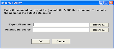
The process is menu driven. Be aware, to enter the output data source without file extension, just the name only. It should close with an ‘Import Complete’ message.
The output is a new folder with some 10-20 files, which is the standard ArcInfo coverage.
2. ArcInfoCoverageToShapefileGUI, based on ogr2ogr in FWTools, will convert the file from the previous step to shape file in a menu-driven way (see Annex 7 for installation of FWTools and ArcInfoCoverageToShapefileGUI, which can be supplied from TCPD-HQ-GIS on request).
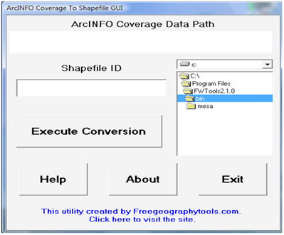
This process is menu driven.
The output is a set of shape files (SHX, DBF, SHP) with a new file name including:
_LAB for points
_ARC for lines
_PAL for polygons
_CNT for polygon centroids
At the end, this shape file is to be converted to a Map Maker DRA file. This is explained in Chapter 5.4.1 (Import GIS data from ESRI/ SHP format).

