A8. Map projection parameters - LUPMISManual
Main menu:
Annex 8: Map Projection Parameters
Level of expertise required for this Chapter: Advanced; specifically for LUPMIS @ TCPD
The Survey Department has announced, that as of January 2009 for all major official jobs, mapping products will be delivered in the international WGS 84-based UTM projection. This was overrules by a later decision of the new Survey & Mapping Division of the Lands Commission, in favour of the newly established Ghana Transverse Mercator projection (GTM)
There are currently five conversion parameters available (four provisional sets published by the Survey Department, and one informal). None of them are final and official to convert from War Office to UTM 30. The Survey Department will officially switch to GTM, when the second phase of the GRN exercise is complete all over Ghana.
| Survey Dept 1 | Survey Dept 2 | Survey Dept 3 | Ayer | SD: Guidelines | GTM | |
| ||||||
x ('x0') | 6,339,239.290 | 0 | 0 | 6,378,137 (?) | 6,361,565 | ? |
y ('y0') | -120,750.511 | 0 | 0 | 6,356,752 (?) | 6,340,073 | ? |
1:f | 61.405 | 298.253 | 298.253 | 298.257 | 296 | ? |
| ||||||
Method | 7 parameters (Helmert/ | 7 parameters (Helmert/ | 5 parameters | 5 parameters | ? | ? |
dx (m) | -196.557 | -158.635 | -196.580 | -196.24 | ||
dy (m) | 33.385 | 32.174 | 33.383 | 33.38 | ||
dz (m) | 322.452 | 326.783 | 322.552 | 322.76 | ||
rx (radians) | 1.786E-7 = | 1.786E-7 = | 0 | - | ||
Rx (seconds) | 0.036,838,89 | 0.036,838,89 | - | - | ||
ry (radians) | -3.872E-8 = | -3.872E-8 = | 0 | - | ||
Ry (seconds) | -0.007,986,57 | -0.007,986,57 | - | - | ||
rz (radians) | -5.767E-8 = | -5.767E-8 = | 0 | - | ||
Rz (seconds) | -0.011,895,29 | -0.011,895,29 | - | - | ||
scale | 0.999,994,0 | 0.999,992,4 | 1 | - | ||
da | - | - | -163 | |||
df | - | - | -2.5567E-5 | |||
| ||||||
Type | TM | |||||
Origin x (º) | 1º W | |||||
Origin y (º) | 4.66666666º N | |||||
False x (m) | 274,320 | |||||
False y (m) | 0 | |||||
Scale | 0.999,75 | |||||
Units | Meters | |||||
Bold: Original published by Survey Dept
Italics, with (?): Assumption
Note 1: Assumption that y0 is the difference to minor axis of WGS 84, not the minor axis itself
Note 2: Assumption that base is WGS 84 ellipsoid
Note 3: Consideration of given df factor, irrelevant for practical application
- - - - -
Map projection definitions can be defined (in this sequence) in Map Maker with following steps:
- 1. Ellipsoid: Main menu > Utilities > Latitude and Longitude utilities > Datum > Create datum > Create ellipsoid > Enter name: WarOffice ellipsoid
> Enter semi-axis major (for War Office, best: 6378300) >
> Enter flattening (not minor axis)(for War Office, best: 296) >
Semi-axis minor should come up with 6356752) > OK > OK
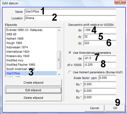
- 2. Datum: Main menu > Utilities > Latitude and Longitude utilities > Datum > Create datum > Enter name: WarOffice (see 1, below) > Enter location: Ghana (see 2) > Select ellipsoid: WarOffice ellipsoid (see 3) > Enter geocentric shift:
> dx (for War Office, best: -199) (see 4) >
> dy (for War Office, best: 32) (see 5) >
> dz (for War Office, best: 322) (see 6) >
Enter Molondenski parameters:
> da (for War Office, best: -81.5) (see 7) >
> df*10000 (for War Office, best: -0.255) (see 8) > OK
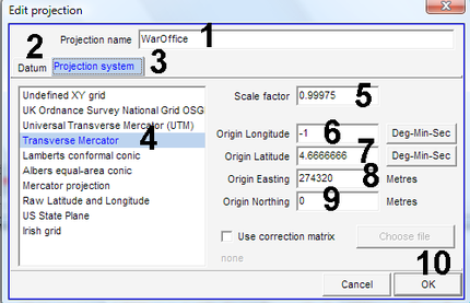
- 3. Projection: Main menu > Utilities > Latitude and Longitude utilities > Create projection > Enter Projection name: WarOffice (see 1, below) > Datum (2) > Select datum: WarOffice > Projection system (3) > Select projection (for War Office, ‘Transverse Mercator’) (4) > Enter projection parameters:
> Scale factor (for War Office: 0.99975) (5) >
> Origin Longitude (for War Office: -1) (6) >
> Origin Latitude (for War Office: 4.6666666) (7) >
> Origin Easting (for War Office: 274320) (8) >
> Origin Northing (for War Office: 0) (9) > OK
- - - - -
See Annex 1.1.5 for entry of standard projection, Annex 2.2 for background of projection and datum.

