5.1.2 Import list of points from Excel file - LUPMISManual
Main menu:
- 0. Introduction
- 1. GIS handling
-
2. GIS data entry
- 2.1 Create new layer
- 2.2 Digitize line
- 2.3 Digitize point
- 2.4 Digitize polygon
- 2.5 Edit existing layer
- 2.6 Delete feature
- 2.7 Split line
- 2.8 Split polygon
- 2.9 Merge lines from different layers
- 2.10 Unite lines
- 2.11 Snap lines
- 2.12 Join polygons
- 2.13 Extend polygon
- 2.14 Insert island
- 2.15 Define unit surrounding islands
- 2.16 Create 'doughnut'
- 2.17 Fill 'doughnut' polygon
- 2.18 Fill polygon with 'holes'
- 2.19 Digitize parcels from sector layout
-
3. GIS operations
- 3.1 Create buffer
- 3.2 Create exclusion zone
- 3.3 Overlay units
- 3.4 Convert line to polygon
- 3.5 Derive statistics (area size, length)
- 3.6 Clip unit according to other unit
- 3.7 Create geographic grid
- 3.8 Move entire vector map
- 3.9 Move or copy individual features on a map
- 3.10 Adjust polygon to line
- 3.11 Convert points to polygon
- 3.12 Define by distance
- 3.13 Create multiple objects
- 3.14 Transfer styles from one layer to another
-
4. Attribute database
- 4.1 Start with database
- 4.2 Import database
- 4.3 Display database information
- 4.4 Enter attribute data
- 4.5 Attribute matrix of multiple layers
- 4.6 Seeds
- 4.7 Repair attribute data
- 4.8 Merge lines with attached database
- 4.9 Transfer attribute data from points to polygons
- 4.10 Copy styles, labels, attributes
-
5. Conversion of data
-
5.1 Points
- 5.1.1 Import list of points from text file
- 5.1.2 Import list of points from Excel file
- 5.1.3 Convert point coordinates between projections
- 5.1.4 Convert point coordinates from Ghana War Office (feet)
- 5.1.5 Convert point coordinates from Ghana Clark 1880 (feet)
- 5.1.6 Track with GPS
- 5.1.7 Download GPS track from Garmin
- 5.1.8 Download GPS track from PDA
- 5.1.9 Frequency analysis of points
- 5.2 Vector maps
- 5.3 Raster maps
-
5.4 Communication with other GIS programs
- 5.4.1 Import GIS data from SHP format
- 5.4.2 Import GIS data from E00 format
- 5.4.3 Import GIS data from AutoCAD
- 5.4.4 Export LUPMIS data to other programs
- 5.4.5 Export GIS to AutoCAD
- 5.4.6 Change a shape file to GPX
- 5.4.7 Transfer GIS data to other LUPMIS installations
- 5.4.8 Digitize lines in Google Earth
- 5.5 Terrain data
- 5.6 Export to tables
- 5.7 Density map
-
5.1 Points
-
6. Presentation
- 6.1 Labels
- 6.2 Styles and Symbols
- 6.3 Marginalia
- 6.4 Legend
- 6.5 Map template
- 6.6 Final print
- 6.7 Print to file
- 6.8 3D visualization
- 6.9 External display of features
- 6.10 Google
-
7. GIS for land use planning
- 7.1 Introduction to land use planning
- 7.2 Land use mapping for Structure Plan
- 7.3 Detail mapping for Local Plan
- 7.4 Framework
- 7.5 Structure Plan
- 7.6 Local Plan
- 7.7 Follow-up plans from Local Plan
- 7.8 Land evaluation
-
8. LUPMIS Tools
- 8.1 General
-
8.2 Drawing Tools
- 8.2.1 Overview
- 8.2.2 UPN
- 8.2.3 Streetname + housenumbers
- 8.2.4 Lines
- 8.2.5 Arcs
- 8.2.6 Polygons
- 8.2.7 Points
- 8.2.8 Cut line
- 8.2.9 Other Drawing Tools
- 8.2.10 Import
- 8.2.11 Projections + conversions
- 8.2.12 Format conversion
- 8.2.13 Other GIS Tools
- 8.2.14 Utilities
- 8.3 Printing Tools
- 8.4 Permit Tools
- 8.5 Census Tools
-
8.6 Revenue Tools
- 8.6.1 Overview
- 8.6.2 Entry of revenue data
- 8.6.3 Retrieval of revenue data
- 8.6.4 Revenue maps
- 8.6.5 Other revenue tools
- 8.7 Reports Tools
- 8.8 Project Tools
- 8.9 Settings
-
9. Databases
- 9.1 Permit Database
-
9.2 Plans
- 9.2.1 Accra
- 9.2.2 Kasoa
- 9.2.3 Dodowa
- 9.2.4 Sekondi-Takoradi
-
9.3 Census Database
-
9.4 Revenue Database
-
9.5 Report Database
-
9.6 Project Database
- 9.7 Address Database
-
Annexes 1-10
- A1. LUPMIS setup
- A2. Background to cartography/raster images
- A3. Glosssary
- A4. Troubleshooting
- A5. Styles
- A6. Classification for landuse mapping/planning
- A7. GIS utilities
- A8. Map projection parameters
- A9. Regions / Districts
- A 10. Standards
-
Annexes 11-20
- A11. LUPMIS distribution
- A12. Garmin GPS
- A13. Training
- A14. ArcView
- A15. Population statistics
- A16. Entry and display of survey data
- A17. External exercises
- A18. Programming
- A19. Paper sizes
- A20. Various IT advices
- A21. Site map and references
5.1.2 Import List of Points from Excel
Level of expertise required for this Chapter: Intermediate; general Map Maker training
1. Create a file of points in Excel
In Excel, create a new spreadsheet and enter (or import) following fields:
ID: Containing consecutive numbers, 1, 2, 3 …
E: Containing the UTM easting coordinates of the points
N: Containing the UTM northing coordinates of the points
Type: Containing the style number of each point
Label (to be displayed at the map)
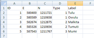
‘Type’ and ‘Label’ are optional (not necessary).
Any additional data fields can be imported only to the attached database (see Chapter 4.2 for the procedure to start with new database).
It is recommended to use these field (column) names, but not necessary. Have row 1 as the header row, with the names of the fields. If you do not have the coordinates in UTM, you should convert them to UTM, if you have only a few, or should enter them in latitude / longitude degrees and convert them later to UTM, if you have many.
- - - - -
2. Save this file as an XLS file (not as XLSX). (In MS Office 2007: ‘Save As’ > MS Excel 97-2003 Workbook operation)
- - - - -
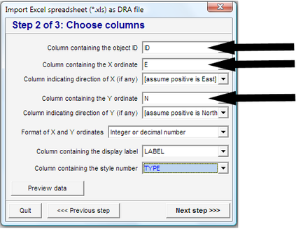
3. In Map Maker: Main menu > Utilities > Vector utilities > Import files > Excel spreadsheet with XY > Step 1of 3 window: Choose source XLS file > Select folder > Select XLS file, as created in the previous step > Open > Choose table window: Sheet 1 > OK > Next step > Step 2 of 3 window: Assign references:
Column containing the object ID: ID
Column containing the X coordinate: X
In most of Ghana, the X coordinates are to the West (not East). If there are entered as lat/long with positive values to the West: Assuming positive is West. (If they are entered in UTM or in negative values, leave default)
Column containing the Y coordinate: Y
Format of X and Y coordinates: Leave default of ‘Integer or decimal number’
Column containing the display label: Label (if exists, otherwise leave blank)
Column containing the style number: Type (if exists, otherwise leave blank)
> Next step >
> Step 3 of 3 window: Choose target file > Specify new, temporary file name > Save > Finish > Confirm save
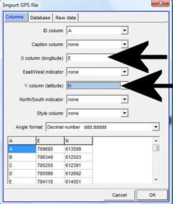
Alternatively: Main menu > Utilities > GPS utilities > Import data > Comma separated text, select file type (*.csv), select folder and file
- - - - -
4. Display this map in Map Maker, check and see the coordinate system (bottom left, see also Annex 2.1 to differentiate between UTM and lat / long).
- - - - -
5. If these coordinates are in lat / long, you have to convert them to UTM 30: Main menu > Utilities > Latitude and Longitude > WGS84 Lat/Long file to xy > Vector > Choose target XY map projection window: Select UTM 30 (if not listed, see Annex 1.1.5) > OK > Choose file window: Select folder and file > Choose or name a file window: Select folder > Enter file name > Save

