7.4.1 Concept of Framework - LUPMISManual
Main menu:
- 0. Introduction
- 1. GIS handling
-
2. GIS data entry
- 2.1 Create new layer
- 2.2 Digitize line
- 2.3 Digitize point
- 2.4 Digitize polygon
- 2.5 Edit existing layer
- 2.6 Delete feature
- 2.7 Split line
- 2.8 Split polygon
- 2.9 Merge lines from different layers
- 2.10 Unite lines
- 2.11 Snap lines
- 2.12 Join polygons
- 2.13 Extend polygon
- 2.14 Insert island
- 2.15 Define unit surrounding islands
- 2.16 Create 'doughnut'
- 2.17 Fill 'doughnut' polygon
- 2.18 Fill polygon with 'holes'
- 2.19 Digitize parcels from sector layout
-
3. GIS operations
- 3.1 Create buffer
- 3.2 Create exclusion zone
- 3.3 Overlay units
- 3.4 Convert line to polygon
- 3.5 Derive statistics (area size, length)
- 3.6 Clip unit according to other unit
- 3.7 Create geographic grid
- 3.8 Move entire vector map
- 3.9 Move or copy individual features on a map
- 3.10 Adjust polygon to line
- 3.11 Convert points to polygon
- 3.12 Define by distance
- 3.13 Create multiple objects
- 3.14 Transfer styles from one layer to another
-
4. Attribute database
- 4.1 Start with database
- 4.2 Import database
- 4.3 Display database information
- 4.4 Enter attribute data
- 4.5 Attribute matrix of multiple layers
- 4.6 Seeds
- 4.7 Repair attribute data
- 4.8 Merge lines with attached database
- 4.9 Transfer attribute data from points to polygons
- 4.10 Copy styles, labels, attributes
-
5. Conversion of data
-
5.1 Points
- 5.1.1 Import list of points from text file
- 5.1.2 Import list of points from Excel file
- 5.1.3 Convert point coordinates between projections
- 5.1.4 Convert point coordinates from Ghana War Office (feet)
- 5.1.5 Convert point coordinates from Ghana Clark 1880 (feet)
- 5.1.6 Track with GPS
- 5.1.7 Download GPS track from Garmin
- 5.1.8 Download GPS track from PDA
- 5.1.9 Frequency analysis of points
- 5.2 Vector maps
- 5.3 Raster maps
-
5.4 Communication with other GIS programs
- 5.4.1 Import GIS data from SHP format
- 5.4.2 Import GIS data from E00 format
- 5.4.3 Import GIS data from AutoCAD
- 5.4.4 Export LUPMIS data to other programs
- 5.4.5 Export GIS to AutoCAD
- 5.4.6 Change a shape file to GPX
- 5.4.7 Transfer GIS data to other LUPMIS installations
- 5.4.8 Digitize lines in Google Earth
- 5.5 Terrain data
- 5.6 Export to tables
- 5.7 Density map
-
5.1 Points
-
6. Presentation
- 6.1 Labels
- 6.2 Styles and Symbols
- 6.3 Marginalia
- 6.4 Legend
- 6.5 Map template
- 6.6 Final print
- 6.7 Print to file
- 6.8 3D visualization
- 6.9 External display of features
- 6.10 Google
-
7. GIS for land use planning
- 7.1 Introduction to land use planning
- 7.2 Land use mapping for Structure Plan
- 7.3 Detail mapping for Local Plan
- 7.4 Framework
- 7.5 Structure Plan
- 7.6 Local Plan
- 7.7 Follow-up plans from Local Plan
- 7.8 Land evaluation
-
8. LUPMIS Tools
- 8.1 General
-
8.2 Drawing Tools
- 8.2.1 Overview
- 8.2.2 UPN
- 8.2.3 Streetname + housenumbers
- 8.2.4 Lines
- 8.2.5 Arcs
- 8.2.6 Polygons
- 8.2.7 Points
- 8.2.8 Cut line
- 8.2.9 Other Drawing Tools
- 8.2.10 Import
- 8.2.11 Projections + conversions
- 8.2.12 Format conversion
- 8.2.13 Other GIS Tools
- 8.2.14 Utilities
- 8.3 Printing Tools
- 8.4 Permit Tools
- 8.5 Census Tools
-
8.6 Revenue Tools
- 8.6.1 Overview
- 8.6.2 Entry of revenue data
- 8.6.3 Retrieval of revenue data
- 8.6.4 Revenue maps
- 8.6.5 Other revenue tools
- 8.7 Reports Tools
- 8.8 Project Tools
- 8.9 Settings
-
9. Databases
- 9.1 Permit Database
-
9.2 Plans
- 9.2.1 Accra
- 9.2.2 Kasoa
- 9.2.3 Dodowa
- 9.2.4 Sekondi-Takoradi
-
9.3 Census Database
-
9.4 Revenue Database
-
9.5 Report Database
-
9.6 Project Database
- 9.7 Address Database
-
Annexes 1-10
- A1. LUPMIS setup
- A2. Background to cartography/raster images
- A3. Glosssary
- A4. Troubleshooting
- A5. Styles
- A6. Classification for landuse mapping/planning
- A7. GIS utilities
- A8. Map projection parameters
- A9. Regions / Districts
- A 10. Standards
-
Annexes 11-20
- A11. LUPMIS distribution
- A12. Garmin GPS
- A13. Training
- A14. ArcView
- A15. Population statistics
- A16. Entry and display of survey data
- A17. External exercises
- A18. Programming
- A19. Paper sizes
- A20. Various IT advices
- A21. Site map and references
7.4 Framework
7.4.1 Concept of Framework
Level of expertise required for this Chapter: Planner; specifically for LUPMIS @ TCPD
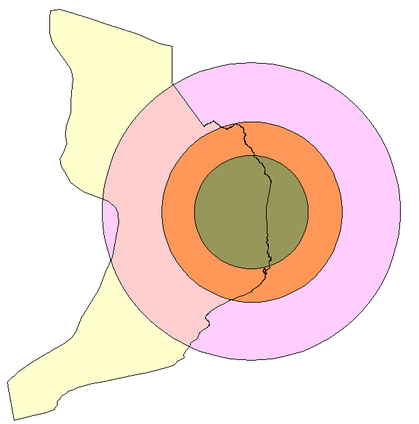
A Framework (Spatial Development Framework, SDF) has an indicative, ‘thematic’ map, showing where development activities and investments are to occur in a longer time frame.
Frameworks do not have precisely delineated units, but show cartographic symbols of corridors and circles, not actual spatial mapping units.
Concepts are derived from general plans on national and regional scales, and from economic and social planning considerations of the Medium Term Development Plan (MTDP).
If no MTDP exists, it is up to the planner in this stage, to express economic targets, and to define them in a crude spatial context.
Remember, a Framework is a visualization of political concepts for development, rather ideas than precise maps – unlike the Structure Plan. Requirements for precise location of geographical data are therefore not high.
The following two Chapters will illustrate the workplan (step-by-step guide, Chapter 7.4.2), primarily addressed to planners, and the GIS procedures in Map Maker to execute these steps ( Chapter 7.4.3), primarily addressed to any GIS user.
See also Chapter 7.1.1 for the role of the Framework within the entire planning concept, and its further description.
- - - - -
Don’t forget:
Though land use planning is based on defined methodologies, uses new technologies and requires accurate data, planning itself is not a science.
Planning is ‘manipulation for a better future’.
- - - - -
Background of spatial planning:
Planning at this level is a consideration of three basic spatial planning concepts:
Development of corridors
Development of subcentres (‘nodes’)
Development of a centre
or a sound balance of these spatial concepts.
A) Corridor development takes places along major axis in ‘buffer areas’, which are in most cases roads, either existing or improved or planned. This is also called 'arterial development'.
The buffer command in Map Maker is a very useful tool to define the spatial extension of buffers (see next Chapter, step 3).

B) Subcentre development is the planning and promotion of a number of centres in the entire planning area (also called ‘nodes’ or 'nodal development'). Size, functionality and distances of these subcentres have to be carefully planned. Not necessarily they are identical to each other.
GIS tools of creating circles and round buffers are the adequate means to define and visualize such subcentres (see next Chapter, steps 4 and 5).
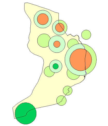
C) Development of a (new or existing) centre is also a concept useful in some geographical areas and in some fields, in particular with functionalities which depend on a higher central level, i.e. not on a widespread use, such as higher administrative or service functions.
Like the spatial extension of subcentres, the GIS tools of creating circle and round buffers will be applied at the GIS.